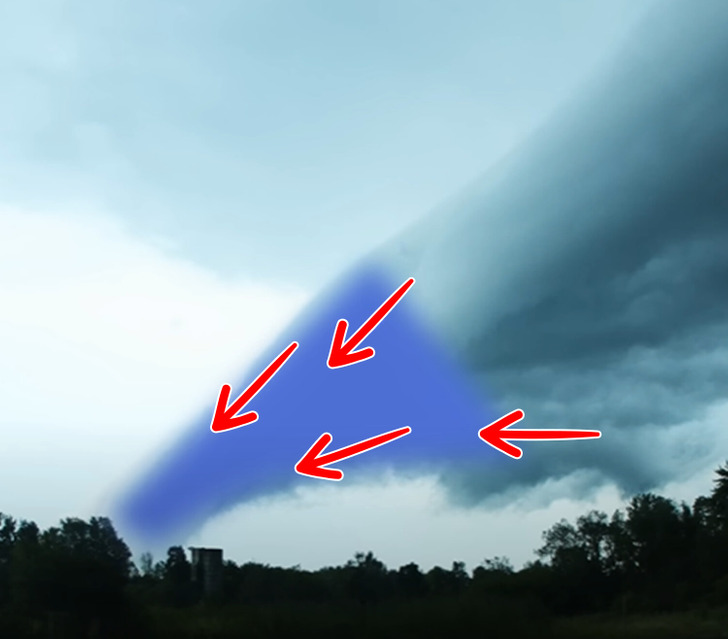
Have you ever seen a fog racing towards you or a cloud formation resembling a tsunami? Or was it a funnel cloud that looked like a tornado was about to form? Before you freak out, you probably saw a scud cloud, an intriguing and frequently misunderstood meteorological phenomenon.

The term “Scud” is an acronym for “Stratocumulus Under Deck,” indicating that these clouds form at low heights, have a fluffy appearance, and produce little rain. Essentially, they are low-lying Stratocumulus clouds with unique wispy, finger-like shapes that almost touch the ground, forming below other cloud layers.
The formation of Scud Clouds is closely tied to humidity. During a rainstorm, warm, moist air is lifted vertically into the atmosphere — known as an updraft. As the air rises, it cools, leading to condensation and the formation of clouds. Scud Clouds, however, occur when the air is so humid that it becomes saturated close to the surface, triggering condensation at lower levels, separate from the rest of the clouds.
Additionally, Scud Clouds may also form due to cold fronts, where pockets of warm, moist air linger near the surface as cooler air rushes in, leading to condensation close to the ground. This results in the striking visual display of Scud Clouds.

While scud clouds are generally harmless, they often accompany powerful thunderstorms. It’s important to note that scud clouds are frequently observed on the leading edge of a storm. One interesting characteristic of scud clouds is that they can move at different speeds than the actual thunderstorm itself. However, it is essential to remain vigilant, as their presence might indicate a concerning weather situation.
Stay with us, and let your curiosity be your guide as we venture into uncharted territories of knowledge and understanding. Together, we’ll unravel the enigmas that captivate our minds and spark a lifelong desire for exploration and learning.